Trek to Narayangad Fort - Amba Ambika Caves
On
the weekend of July 6, we went to a half day trek to Narayangad
followed by a visit to Amba Ambika Caves in Narayangaon.
 |
| Narayangad seen from the base village, Gadachi Wadi |
Co
travelers were me, Nirupa, Ashutosh with his son Aarush, Pritesh,
Vishal with his wife Aryaa and son Ved.
 |
| L to R - me, Aditya, Nirupa, Aryaa, Vishal, Aarush, Pritesh, Ashutosh, Ved. |
How
to reach - Narayangaon
We
left early morning by 5.30 am. We travelled in 2 cars. The route we
took was as follows.
Pune
- Nashik Fata - Bhosri - Chakan - Rajgurunagar - Manchar - Khodad -
Narayangaon.
Pune
- Narayangaon - 100 km.
The
road condition was simply fantastic. Except almost 70% of the road is
4 lane with a divider. There is a Narayangaon bypass road in progress
before you enter the town.
Around
7.30 am we halted for a breakfast in Rajgurunagar. There are number
of food joints on the highway between Rajgurunagar and Manchar.
 |
Must try Misal & Wadapav here.
|
How to reach - Narayangad
As you enter Narayangaon, you can spot the State Transport bus stand on left.
As you enter Narayangaon, you can spot the State Transport bus stand on left.
Take
a right turn in the square after you pass the bus stand for
Narayangad, for Amba Ambika Caves take a left turn in the same
square. We visited the fort first and then the caves.
As
you take a right turn you approach a Y junction, both the roads take
you to the fort. Choose the road on the right as it is in very good
condition. 4-5 km of drive and you reach Narayanwadi or Gadachi Wadi,
the base village of the fort.


Narayangad
Fort
History
“The fort is from the Satvahana era and was used as a watch point for the Junnar Paithan route. The fortress is said to have been rebuilt by the first Peshwa Balaji Vishvanath (1714-1720) and given in saranjam or service-grant to Sayaji Povar. In the last Maratha war of 1818 Narayangad is said to have surrendered to the British in 1818 . “ - Wikipedia
“The fort is from the Satvahana era and was used as a watch point for the Junnar Paithan route. The fortress is said to have been rebuilt by the first Peshwa Balaji Vishvanath (1714-1720) and given in saranjam or service-grant to Sayaji Povar. In the last Maratha war of 1818 Narayangad is said to have surrendered to the British in 1818 . “ - Wikipedia
About
The fort is easily accessible from the village. There is a temple of Goddess Mukai at its base. The temple is well maintained and there are two large covered halls on both the sides. Also there is ample space around the temple for parking.
There
are steps of the left side of the temple, that take you to the fort.
Almost half of the climb is by those steps. Later half contains a
plain climb with some narrow rocky patches on the way. You need to be
careful while crossing the rocky patches especially during rains.
Overall the climb is very easy and within half n hour you reach the top of the fort (gadmatha).
As
you can see in the image, the fort is spread horizontally, and the
road takes you to the center of the fort. So you need explore the
right and left sides once you reach the top of the fort. On both the
sides there is some climb. Compared to the left side the path on the
right side is quite narrow and rocky. There
is not much to see on the fort.
On
the right side you can spot number of cisterns on the way. On the
left side you can see some ruins of the fort structure. That includes
a stoned frame of the door with an image of Lord Ganesh engraved in
it. The base structure of the door with tigers chiseled out of stone
on both the sides. Again on the way you can spot a cistern.
At
the end there is a temple of goddess Hastamata. The temple is clean
and offers a shelter for around 20 people if you are planning an
overnight stay.
Although
there are not much remains left on the fort, the view from the fort
is amazing. Especially during the monsoons you can see the green
fields all around. The Khodad GMRT project is something worth a view.
You can also spot fort Shivneri.
 |
| Major part of the trek is done through these steps |
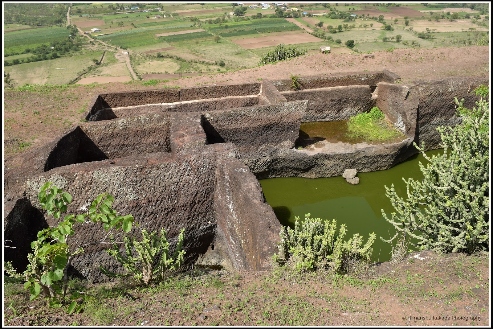 |
| Strategically created cluster of cisterns. |
 |
| Remains of old walls. |
 |
| Water cistern |
 |
| Temple of Hasta Mata is the situated at the peak of the fort. |
 |
| viewing one corner of the fort from the other. |
 |
| Deep Maal (the tower of lights) near the temple. |
 |
| Goddess Hasta Mata |
 |
| View of the trek route from the top. |
 |
| Yet another cistern. |
 |
| Remains from the past. 2 faces of tigers carved in the stones. |
 |
| Ganesh Patti, a stone strip that used to be placed on the entrance door. |
Amba
Ambika Caves
We left the fort by 12.30 PM, had our lunch at Jeevan restaurant and left for the caves.
About
As you approach the Shivaneri fort, the caves can be easily spotted on your left. All the caves are from Hinayan period dated back to 3rd century.
You can get details about these caves here (Courtesy - Kevin Standage)
How to reach - Amba Ambika Caves
How to reach - Amba Ambika Caves
Amba
Ambika caves are Buddhist caves located around 13 km from
Narayangaon. Take immidiate left after Narayangaon bus stand or you
go straight past the bus stand for couple of kilometers and take left
for a bypass road. On that road, take a left after Indian Oil petrol
pump and drive for another kilometer. You can spot a poultry farm on
your right. A walk way goes behind the farm for the Amba Ambika
caves.
A
smooth trail of 15 mins upwards can take you to the caves.
 |
| Road to the caves. Take right at this Y junction. |
 |
| Beware of honey bees on the road to the caves. |
 |
| First view of the caves as you enter the place. |
 |
| stone carved columns, supporting the heritage. |
 |
| A small Stupa at the outside. At the second level on the left side, there are carvings of Amba & Ambika. |
 |
| An incomplete Stupa inside the Garbh Griha |
 |
| The Stupa |
 |
| Inscriptions in Pali language |
 |
| Images of goddesses Amba & Ambika |
 |
| Images of goddesses Amba & Ambika |
 |
| Walls inside the cave are covered with Red & Yellow. The colors of Kunkum & Haladi. |
 |
| The meditating Buddha inscribed on on one of the walls. |
 |
| Narrow space to visit the Amba Ambika section at the second level of the caves. |
 |
| On our way back to the base. Happy & Satisfied. |
Khodad
GMRT Project
 |
| GMRT Telescope. Connecting earth to the space. |
 |
| There are total 21 telescopes spotted from the fort. |
On our way back we took a tea break at the same Aakash restaurant and then dispersed. Overall it was a nice day trip.
2) Ojhar
Ganesh Temple - 11 km.
3) Lenyadri
Ganesh Temple - 22 km.
4) Malshej
Ghat - 44 km.
GPS
Co-ordinates
1) Hastamata
Temple, base of Fort Narayangad. - 19.113348,
74.033289
2) Amba
Ambika Caves, Junnar. - 19.188642,
73.887991
Total
Expenses
1) Nashik
Road Toll - Rs. 74 (Return)
2) Fuel
- Rs.1000 per car. (Distance 220 km with Rs.75 per litre for Avg.17
km/lt)
3) Breakfast
- Hotel Akash. - Rs.
975 for 9 people.
4) Lunch
- Hotel Jeevan, Narayangaon. - Rs.
740 for 9 people.
5) Evening
snacks - Hotel Akash. - Rs.
330 for 9 people.
Total Cost - Rs.600 per head. (Excluding kids)


Comments
Post a Comment